
Poland, Historical Map Overlay
- Profile
- Images
Location: [unknown]
The following page is for those interested in an overlay map comparing 1900 boundaries to present day Poland boundaries.
- Poniższa strona jest przeznaczona dla osób zainteresowanych nakładkową mapą porównującą granice z 1900 roku z obecnymi granicami Polski.
- Die folgende Seite ist für diejenigen gedacht, die an einer Overlay-Karte interessiert sind, die die Grenzen von 1900 mit den heutigen Grenzen Polens vergleicht.
These images are being provided to anyone interested in understanding historical Poland. You may use any of these images without permission from the creator (Skye) for noncommercial purposes. The intention behind the image creations is to help people understand border changes or name changes of specific geographic areas. People may find these maps useful when tracking migration patterns, name studies, etc. I will provide images with and without labels.
- Obrazy te są udostępniane wszystkim zainteresowanym zrozumieniem historycznej Polski. Możesz używać dowolnego z tych obrazów bez zgody twórcy do celów niekomercyjnych. Intencją tworzenia obrazów jest pomoc ludziom w zrozumieniu zmian granic lub zmian nazw określonych obszarów geograficznych. Ludzie mogą uznać te mapy za przydatne podczas śledzenia wzorców migracji, badań nazw itp. Dostarczę obrazy z etykietami i bez nich.
- Diese Bilder werden jedem zur Verfügung gestellt, der sich für das historische Polen interessiert. Sie dürfen jedes dieser Bilder ohne Genehmigung des Erstellers für nichtkommerzielle Zwecke verwenden. Die Absicht hinter den Bildkreationen besteht darin, den Menschen zu helfen, Grenzänderungen oder Namensänderungen bestimmter geografischer Gebiete zu verstehen. Diese Karten können für die Verfolgung von Migrationsmustern, Namensstudien usw. nützlich sein. Ich werde Bilder mit und ohne Beschriftung bereitstellen.
If you are looking for a particular village via Wikipedia, please switch to the Polish Wikipedia (top right of page gives options for other languages.) When you click on the gmina or the powiat, there typically will be an image of them. This makes it easier for you to accurately locate your village on the map.
- Jeśli szukasz konkretnej wsi za pośrednictwem Wikipedii, przełącz się na polską Wikipedię (prawy górny róg strony daje opcje dla innych języków). Po kliknięciu na gminę lub powiat, zwykle pojawia się ich obraz. Ułatwia to dokładne zlokalizowanie wioski na mapie.
- Wenn Sie über Wikipedia nach einem bestimmten Dorf suchen, wechseln Sie bitte zur polnischen Wikipedia (oben rechts auf der Seite finden Sie Optionen für andere Sprachen). Wenn Sie auf die Gmina oder den Powiat klicken, wird normalerweise ein Bild davon angezeigt. Dies erleichtert Ihnen die genaue Lokalisierung Ihres Dorfes auf der Karte.
Information for making your own edits: That's right! The information is provided for you to make your own edits or improvements. Please always give credit where credit is due, do not pass off someone else's work as your own. That is all that is asked of you. Always re-check your area of interest, especially for villages positioned on borders (for proper name.) Please remember to err is to be human. As I work on village categorization on Wikitree, it will allow me to find errors on the map and I will mention corrections that need to be made.
- Skye used basic paint program on Windows.
- Russian Empire orange border = FF7F27
- Russian Empire brown inside lines = 8A5B40
- Russian Empire gold inside lines = FFC90E
- Kingdom of Galicia and Lodomeria green border = 1E9C43
- Prussia indigo border = 3F48CC
- Light grey background for corrections =F5F5F5
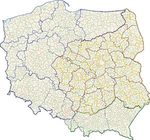
The following image shows the present day administraive boundaries for Poland (gmina, powiat, voivodeship). This image can be found here: https://commons.wikimedia.org/wiki/File:POLSKA_woj_pow_gminy.png (licensed under Creative Commons):

|
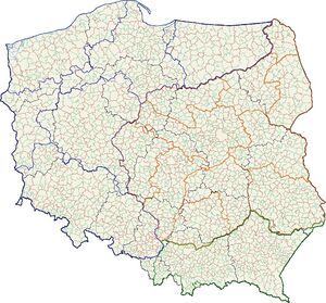
The following image compares present day Poland to what it would have looked like circa 1900 without labels. Skye took the time to study historical maps of Prussia, Russian Empire and Kingdom of Galicia and Lodomeria in order to provide an accurate boundary overlay. Please always be aware that to err is human. Double check your village if it is situated near a boundary line.

|
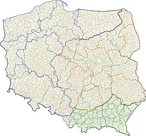
The same image with historical labels vs. present day voivodeships:

|
The same image with administrative districts (bezirke) within the Kingdom of Galicia and Lodomeria:

|
The same image with administrative districts (bezirke) within the Kingdom of Galicia and Lodomeria with labels:

|
The same image with administrative districts (district/obwód & governorate/gubernia) within the Russian Empire:

|
The same image with administrative districts (district/obwód & governorate/gubernia) within the Russian Empire with labels:
- Note to fix: NE corner of Pruszków gmina in Pruszków Powiat (Pruszków city) is in Warsaw Uyzed.
- Note to fix: Raciąż Gmina in Płonsk Powiat (3 parts?: Sierpc, Płock; Płonsk, Płock, Płock) will check all villages against the Gazetteer.

|


- Login to request to the join the Trusted List so that you can edit and add images.
- Private Messages: Send a private message to the Profile Manager. (Best when privacy is an issue.)
- Public Comments: Login to post. (Best for messages specifically directed to those editing this profile. Limit 20 per day.)
- Public Q&A: These will appear above and in the Genealogist-to-Genealogist (G2G) Forum. (Best for anything directed to the wider genealogy community.)
edited by Steve Thomas